
Plans submitted for more than 400 houses in Raunds amid traffic and wildlife concerns
An application to build up to 405 houses off London Road, Raunds, has been submitted.
The site, just east of the A45, measures roughly 40 football pitches and is directly next to Howdens. It would substantially increase the size of Raunds, developing on its west side.
The design and access statement from developer Davidsons Homes sets out a clear vision for the proposal.
It reads: “Land west of London Road and south of Meadow Lane will deliver a scheme that is sustainable, attractive and responds appropriately to the unique characteristics of Raunds.
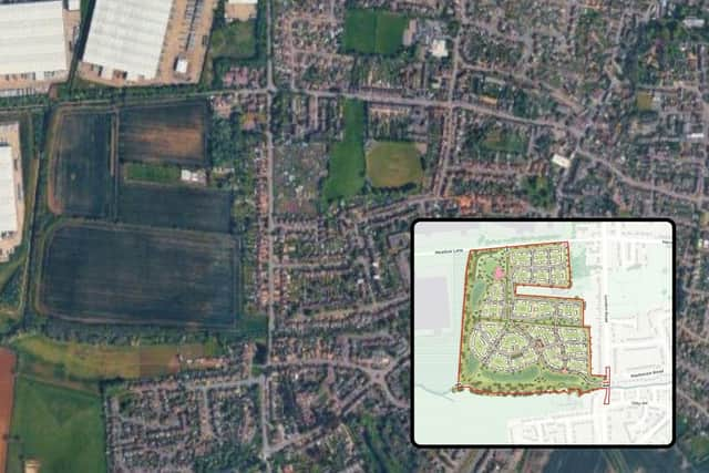

“The proposals are underpinned by robust placemaking principles that will ensure that the scheme delivers healthy living and quality housing within a new neighbourhood, where walking, cycling and access to green infrastructure forms an integral part of everyday living.”
However, residents have been critical of the plans, believing the substantial development will have a negative impact on traffic in the area.
One commenter said: “My biggest concern is road safety.
“London Road is already a busy, constrained route with known safety issues, and this proposal would significantly worsen an already problematic situation.
“The idea of introducing the sole access for a development of 400+ homes onto this already problematic road is deeply concerning.
“This is not simply about congestion or inconvenience, it is about foreseeable and avoidable risk.
“Adding hundreds of additional daily vehicle movements, alongside delivery vehicles, visitors, service traffic, and construction traffic, creates a very real safety concern for motorists, pedestrians, cyclists, school children, and emergency access.”
In October last year, Raunds Town Council admitted to being ‘disappointed’ by a consultation by Davidsons Homes for including ‘leading questions designed to gather data that could support the developer’s case, rather than offering residents an open opportunity to express their views freely’.
Davidsons had said it is ‘conscious of the need for new and affordable housing in the area’ and is ‘carefully considering local planning policies and stakeholder views’ during the finalising of plans.
Plans submitted to North Northants Council and validated this month show the site, which is arable land, split into areas A, B, C, and D, separated by mature low-cut hedgerows.
The application notes that Raunds has experienced ‘consistent, incremental growth since the 1950s’ having been extended both to the north and south of the town, meaning Raunds is ‘a sustainable and accessible location for residential growth’.
Housing will reflect similar developments in Raunds with the majority being two storey buildings, and houses ranging from one, two, three and four-bedroom properties.
Plans also include the provision of a network of footpaths and cycle paths, ensuring better connectivity to the town and nearby Stanwick Lakes, and say more than 40 per cent of the site will be dedicated to green infrastructure.
Another commenter on the now-submitted application added: “The area in question is not only an important amenity for local people who have been using the space for generations for exercise and relaxation, including dog walking but it also represents a very precious wildlife habitat.
“This country is one of the most, if not the most, nature depleted countries in the world – we cannot afford to lose this precious piece of land.
”This piece of land represents a buffer between the massive over-development of industrial space further up London Road and the town of Raunds, which must be preserved.
A third said: “The applicant’s traffic distribution assumptions appear overly optimistic and insufficiently reflective of likely commuter behaviour.
“Given Raunds’ relationship to the A45 corridor and regional employment centres such as Wellingborough, Northampton and Milton Keynes, there is a strong likelihood that a materially greater proportion of peak-hour traffic will route via Stanwick Road than the assessment suggests.
“Existing conditions through Stanwick and associated routes are already constrained by on-street parking and carriageway narrowing, leading to delay, difficulty passing and degraded residential amenity. Even modest increases in concentrated peak-direction traffic are likely to result in disproportionate worsening of conditions.”
The full application can be found online here, or by searching 26/01080/OUT on the North Northants Council planning portal.