Met Office warns two days of record-breaking heat ends with storms over Northamptonshire

and live on Freeview channel 276
Two days of record-breaking heat is set to end with storms hitting Northamptonshire on Wednesday (July 20).
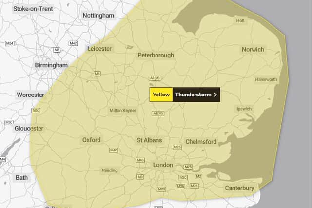
The Met Office has issued a yellow weather warning for heavy showers across across central, southern and eastern parts of England.
Advertisement
Hide AdAdvertisement
Hide AdA spokesman many areas could escape the worst of the weather but added: “Whilst most places will see only small amounts of rain, there is a chance of some isolated heavy downpours and lightning.
“Where these occur a few sites could see 20-30 millimetres in an hour and 50 millimetres in three hours.”
Tomorrow’s warning comes into force at 1pm and lasts until 9pm, although it will still be warm at 25°C.
The Met Office climate station at Pitsford School saw its hottest day on record with a high temperature of 36.2°C at 3.36pm — fractionally hotter than the 36.1°C from July 2020.
Advertisement
Hide AdAdvertisement
Hide AdMaximum air temperature, though, was 38.2°C, smashing the Northamptonshire record of 36.7°C recorded at Raunds on August 9, 1911.

The highest ‘apparent’ temperature was a sweltering 51.5°C at 3.06pm.
Experts predict that could be beaten on Tuesday (July 20) with temperatures up to 40°C widely predicted.

Train companies London Northwestern Railway and East Midlands Railway are telling passengers not to attempt journeys in the county, while the risk of wildfires is at its highest level.
Advertisement
Hide AdAdvertisement
Hide AdA Northamptonshire Fire & Rescue Service spokesman said: “The Met Office Fire Severity Index is an assessment of how severe a fire could become if one were to start. Today for Northamptonshire, it is level five — which means exceptional severity.”