Weather update: Rain, snow and ice forecast as end of March signals start of five-day Arctic blast for Northamptonshire
and live on Freeview channel 276
The last day of March 2022 promises to be a cold and icy one for Northamptonshire as the county gets set for a five-day freeze.
Local forecasters @NNweather warn there could be up to four centimetres of snow in places in the early hours of Thursday (March 31), particularly over hills and higher ground, with a sharp morning frost leading to icy roads and footpaths.
Advertisement
Hide AdAdvertisement
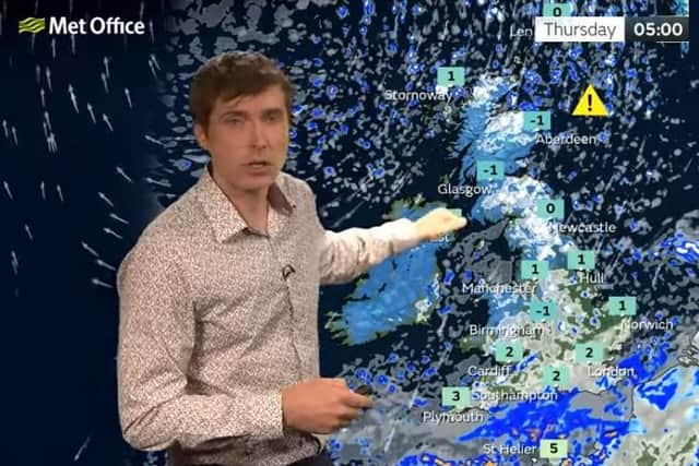
Hide AdMet Office experts stopped short of including the county in a yellow weather warning issued early on Wednesday (March 30). But some predictions say it will feel like MINUS FOUR at 8am on Thursday following hours of rain overnight, which could turn to snow leading to treacherous conditions in places.

And council officials triggered its emergency plans to help rough sleepers and homeless off the streets.
@NNweather tweeted: "The latest radar loop shows the area of rain, with some sleet/snow in places, slowly heading south towards the county.
"Rain tonight may turn to snow in places with a risk of 1-4cm of snow, particularly over any hills, before clearing south followed by a frost with temperatures falling to minus 2°C.
"Some more wintry showers are possible tomorrow."
Advertisement
Hide AdAdvertisement
Hide AdGritters will be out on routes throughout the county while both North and West Northamptonshire councils have triggered Severe Weather Emergency Protocols (SWEP) offering rough sleepers somewhere safe, warm, and dry to stay.
Officials in West Northamptonshire say their SWEP will be running until at least 9am on Monday (April 4), .
■ If you know someone sleeping rough, advise them to contact the homelessness team on 0300 126 7000 or click HERE to inform StreetLink online.
SWEP has two main aims: to ensure no one dies on the streets due to severe weather and that every effort is made to reach out to people sleeping rough to help them get the help they need.
The chill, fuelled by cold winds from the north, lasts until Tuesday according to current Met Office forecasts.
Advertisement
Hide AdAdvertisement
Hide AdMet Office meteorologist Alex Burkill said: “We’ll see temperatures dropping markedly as we go through the next day or two as Arctic air plunges its way across the UK.
"And as a band of rain continues southwards, we’ll likely see a bit more snow as we go through the night.”