
'Stay safe' extreme weather warning issued for Northamptonshire with possible high of 37°C
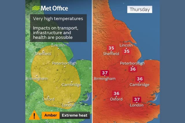

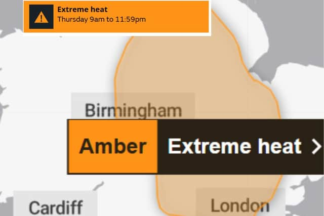
An amber extreme heat warning has been issued by the Met Office with temperatures likely to peak around 37°C in places on Thursday (August 13) in Northamptonshire.
The warning will be in force through much of Thursday and covers parts of southern and eastern England, as well as parts of the Midlands.
Met Office chief forecaster Chris Bulmer said: “While the peak heat will be more short-lived than recent heatwaves, temperatures widely into the mid-30s celsius on Thursday brings the potential for impacts for some, which is why a Met Office warning has been issued.
“High pressure is now becoming dominant and temperatures will build day-by-day.
"Southerly and south-easterly winds will also tap into the hot conditions over Europe which helps develop this further notable heat in what has been a hot and dry summer so far for many in the south of the UK.”
As well as likely health impacts, there could be potential water safety incidents and travel disruption, heat sensitive systems and equipment may also be disrupted, with the potential for power cuts in places.
The UK Health Security Agency has issued heat health alerts, with forecast temperatures likely to cause an increased demand on health and social care services.
William Spencer, climate and first aid expert at the British Red Cross, said: “While periods of hot weather have become more familiar in recent years, they can still pose serious risks to health. In fact, after prolonged dry and warm conditions, it is more important than ever to follow heat safety advice.
“Simple steps such as wearing sunscreen, drinking plenty of fluids, seeking shade during the hottest parts of the day and taking regular breaks from the sun can help protect you and those around you.
"It’s also important to look out for the signs of heat exhaustion and heatstroke, particularly among people who may be more vulnerable to the effects of extreme heat.
“Many communities are also experiencing drought conditions or are in areas at increased risk of wildfires. We encourage everyone to follow advice from local authorities and visit our website for practical guidance on staying safe and supporting anyone who may be at greater risk during periods of extreme heat.”
Thursday will be the peak of the heat this week, but some warmth will remain in the south and southeast on Friday, before easing more widely on Saturday as cooler air spreads south from the north-west.
Advice issued by the Met Office states: “Keep yourself safe by following these simple steps to reduce the likelihood of the heat making you feel unwell; drink plenty of fluids, keep out of the sun and avoid any exercise between 11am and 3pm when the sun is strongest and close curtains in rooms that face the sun.
"If you are going out take water with you, stay in the shade, wear sunscreen and a wide brimmed hat. Give yourself the best chance of avoiding delays by checking road conditions if driving, or bus and train timetables, amending your travel plans if necessary.
"If using public transport, there are many simple things you can do to keep yourself safe; carry water with you, take a small hand-held battery powered fan, if you feel unwell get off at next stop for some fresh air, dress in light fabrics in light colours to help stay cooler, keep an eye on fellow passengers for signs they may be struggling.
"Help to protect vulnerable people that you know including older people, those with underlying conditions and those who live alone; they may need support to keep cool and stay hydrated. If you are worried about your health, or that of somebody you know, ring NHS 111.
"Keep yourself safe whilst enjoying the water in this weather by following these simple steps: enter the water gradually, avoiding jumping or diving straight in, to reduce your risk of cold water shock, go to a lifeguarded beach or a supervised swimming area, and, if you, or anyone else, get into difficulty in the water, float on your back.
"People cope better with power cuts when they have prepared for them in advance. It's easy to do; consider gathering torches and batteries, a mobile phone power pack and other essential items. Stay up to date with the weather forecast for your area and follow any advice from emergency services and local authorities.”
The highest temperatures will be in parts of the east, south-east and the Midlands, where 37 or even 38 Celsius could be reached. This may lead to impacts on transport, infrastructure and health.
All the following areas are at risk:
Derbyshire, Leicestershire, Lincolnshire, Northamptonshire, Nottinghamshire, Rutland, Bedford, Cambridgeshire, Central Bedfordshire, Essex, Hertfordshire, Luton, Norfolk, Peterborough, Suffolk, Thurrock, London & South East England, Bracknell Forest
Buckinghamshire, Greater London, Milton Keynes, Oxfordshire, Reading, Slough, Surrey, West Berkshire, Windsor and Maidenhead
Wokingham, West Midlands, Staffordshire, Stoke-on-Trent, Warwickshire, West Midlands Conurbation, Worcestershire, Yorkshire & Humber
North Lincolnshire, and South Yorkshire.