Medieval settlement in Northamptonshire features in new aerial photography map by Historic England
and live on Freeview channel 276
Today, Historic England launches its new Aerial Photography Explorer - which for the first time allows users to search and explore an online map showing aerial photographs of England over the past 100 years.
Aerial imagery provides a fascinating insight into the development and expansion of the nation’s urban centres and changes to the rural landscape. It can also reveal striking discoveries - such as ‘cropmarks’ showing hidden, archaeology beneath the surface.
Advertisement
Hide AdAdvertisement
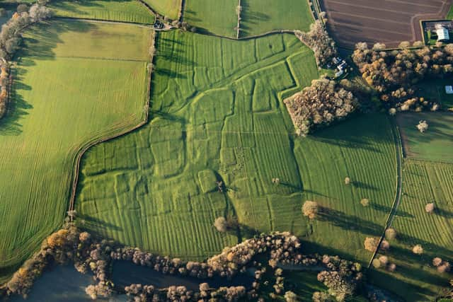
Hide AdThe new imagery includes the remains of ancient archaeology at the medieval settlement of Old Sulby in Northamptonshire broad ditches or ‘hollow way’ - the original main route through the village - can still be seen from striking aerial views. Clearly delineated platforms, once the locations of houses fronting onto the street, were enclosures known as ‘crofts and tofts’ which surrounded houses and their garden plots.

Over 400,000 images from 1919 to the present day have been added to the tool, covering nearly 30% (c.15,000 square miles) of England, allowing people immediate digital access to Historic England’s nationally important collection of aerial photographs.
Around 300,000 of these are the work of Historic England’s Aerial Investigation and Mapping team. Established in 1967, the team takes photographs of England from the air to discover new archaeological sites, create archaeological maps and monitor the condition of historic sites across the country.
The remaining 100,000 images come from the Historic England Archive aerial photography collection, which numbers over two million images in total, and includes important historic photography, including interwar and post-war images from Aerofilms Ltd and The Royal Air Force.
Advertisement
Hide AdAdvertisement
Hide AdBy opening up these images to the public through this accessible online tool, Historic England hopes that people will use it to research their local areas, offering an insight into a century of changes and development. This will allow them potentially to make their own discoveries about their local areas. It will also provide industry professionals and local authorities with a useful resource to help planning, heritage projects and archaeological investigation.
Louise Brennan, Midlands Regional Director, Historic England said: “There is a wealth of fascinating images waiting to be discovered through our new Aerial Photographer Explorer tool. It has been designed to give free, instant access to the sort of photography our team uses every day to map England’s historic past. We hope it will inspire people to delve a little deeper into stories about their local area as well as reminding them how the passing of time and human activity has shaped our built and natural heritage.”